
[Pangyo Interview] Neowise Targets Global Robot and Drone Markets with On-Device Physical AI Technology
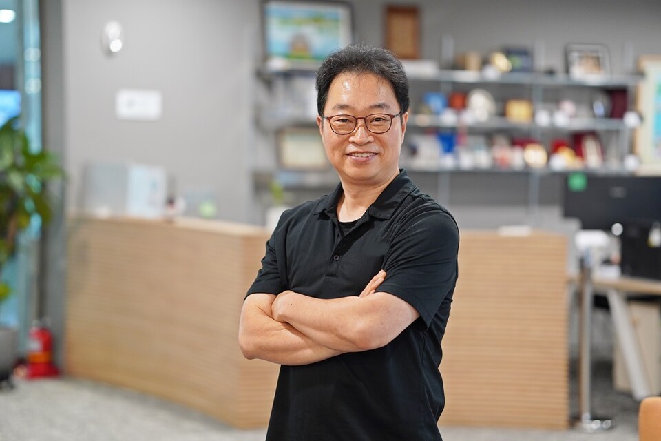
CEO Charlie Shin of Neowise
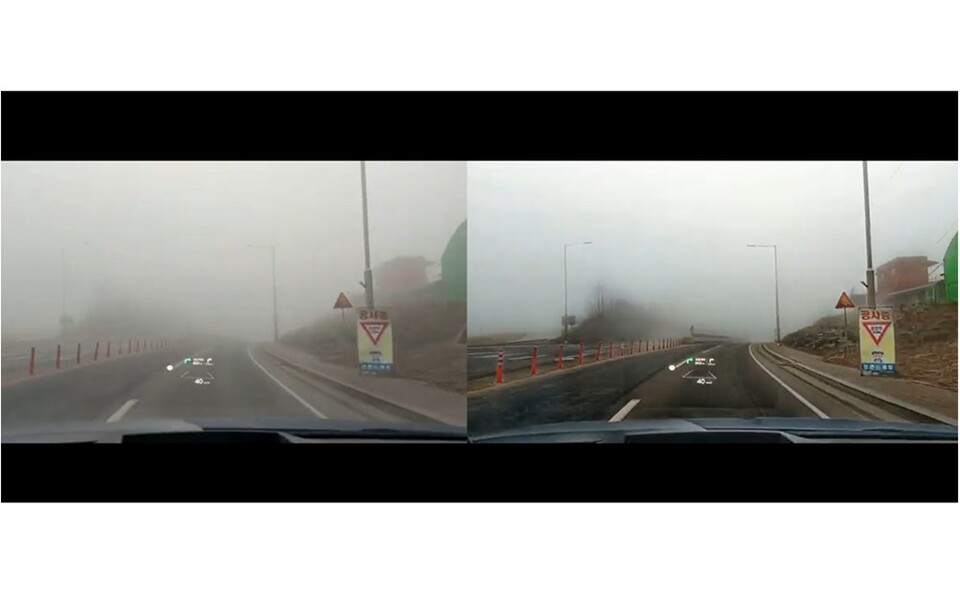
Comparison before (left) and after (right) enhancing foggy road images using NeoSight | Image provided by Neowise
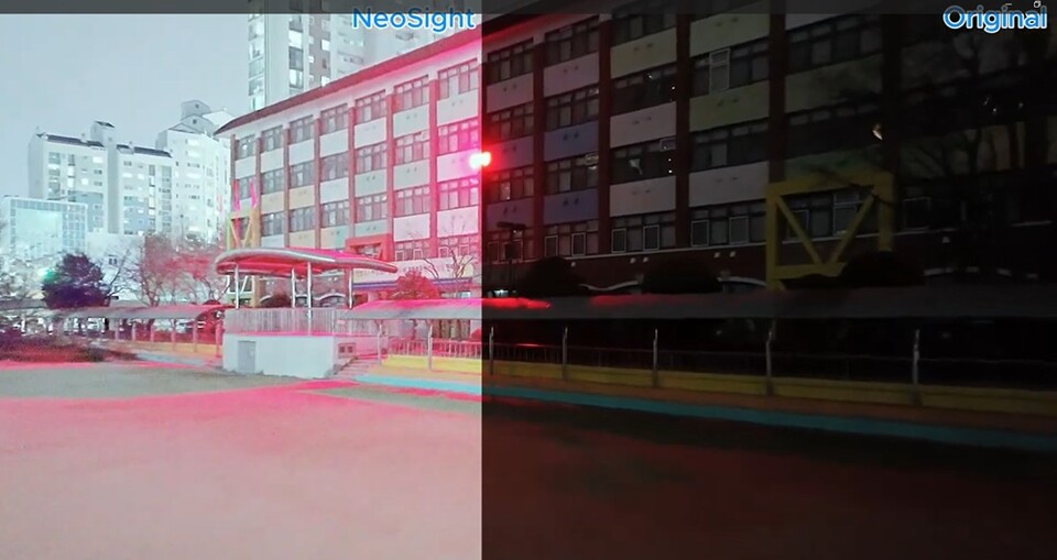
Comparison between image sharpened via NeoSight in a pitch-black low-light environment (left) and original image (right) | Image provided by Neowise
“Our Platform Reduces Cloud Latency and LiDAR Dependence with On-Device NPU Vision and 10-Second Digital Twins for B2B, B2G, and Defense Robotics.”
Founded in April 2024, Neowise adopts the slogan “See, Think, Act”—enabling machines to see the world, understand spatial environments, and act autonomously. To achieve this, the company built a vertically integrated technology stack that connects image restoration technology ‘NeoSight’, digital twin technology ‘NeoTwin’, and an AI training/simulation environment ‘NeoSim’ into a single pipeline.
Core strengths of Neowise’s technology reside in its on-device approach and overwhelming processing speeds. NeoSight restores images in real time directly on Neural Processing Units (NPUs) inside devices without separate cloud servers. Capable of clearly identifying targets even in dark, low-light conditions, fog, or fine dust, it serves as the eyes for robots and drones that must navigate autonomously 24/7. In particular, unlike infrared sensors prone to malfunctions caused by summer insects, NeoSight uses a passive method that utilizes ambient light to deliver clean images, significantly reducing errors in military guard operations.
Furthermore, NeoTwin technology, which converts 2D images into 3D digital twins, drastically cuts conversion time—which previously took days to weeks with traditional surveying methods and 1 to 4 hours with other AI models—down to under 10 seconds to around 1 minute. Replacing expensive, heavy LiDAR sensors that struggle in rainy weather maximizes flight efficiency and stability for drones.
Virtual spaces built via digital twins connect to the NeoSim environment where AI learns autonomously. Following a Real-to-Sim process that transplants real-world spaces directly into simulators to enable repeated training, the ultimate goal is to complete Sim-to-Real, applying capabilities learned virtually to real-world robots and drones.
Training in simulator spaces yields cost reductions exceeding 95% compared to real flight training. Even in environments with numerous no-fly zones, such as Seongnam City, or where night drone flights are legally restricted, teams can configure diverse virtual conditions—such as night or adverse weather — based on 2D images captured during the daytime to conduct safe, repeated training.
Based on this proprietary technology pipeline, Neowise aims to develop and distribute dedicated operating systems (OS) for robots and drones, and to grow into a high-tech enterprise that surpasses global leaders like Palantir.
Earning recognition for its technological capability, Neowise was selected for TIPS and the Early Startup Package, successfully attracting seed investment at a pre-money valuation of 8 billion KRW. Currently targeting the construction Physical AI market for progress rate management and safety inspections as its primary focus, the company is expanding its business to inspect hard-to-reach industrial infrastructure such as bridges and power towers, alongside disaster response sectors where understanding field conditions within the 72-hour golden time proves critical. Having established a local entity in Delaware, US, in October 2025 to launch global expansion in earnest, Neowise pursues entry into North America, Japan (with high demand for earthquake and disaster response), and Middle Eastern markets (Saudi Arabia, UAE) that are active in large-scale construction projects.
Pangyo TV met with Neowise CEO Charlie Shin at the Startup Campus in Pangyo Techno Valley to discuss their Physical AI pipeline, on-device NPU vision engines, and upcoming global market expansion. Reporter Thomas Frederiksen conducted the interview.
Q1. Thomas Frederiksen, Reporter: Can you introduce your company for us? What kind of company is Neowise?
A. Charlie Shin, CEO of Neowise: You can think of ‘Neowise’ as a combination of two words: ‘Neo’ and ‘Wisdom’. Back in 2020, I took my daughter to an observatory, and as we looked up at the night sky, a comet passed by—Comet NEOWISE. My daughter was so captivated by it that I promised her if I ever started another company, I would name it Neowise. That is how our company came to be.
Q2. What core problems is Neowise solving in the technology space?
A. Charlie Shin: AI is increasingly manifesting as Physical AI in our real-world spaces. When AI integrates with the physical world, the first step is to digitize our real-world environment into a 3D simulation space where robots and drones can continuously train before deploying in the physical world. Neowise enables this entire physical AI pipeline through three core technologies: NeoSight, an NPU-driven AI vision enhancement engine that restores clear visibility in dark or foggy environments; NeoTwin, real-time 2D-to-3D spatial reconstruction technology; and NeoSim, a simulation engine that allows robots and drones to train and simulate tasks safely.
Q3. Your company offers these three services—NeoSight, NeoTwin, and NeoSim—which operate as an interconnected pipeline. Can you explain the exact steps of how they work together?
A. Charlie Shin: If a robot or drone is operating autonomously, it needs to function 24/7. Earth has nighttime and low-light conditions, so NeoSight brightens dark environments and clears dense fog or smog in real time, directly on edge NPU hardware, without altering structural fidelity. Next, NeoTwin eliminates the need for expensive, heavy LiDAR sensors by converting standard 2D camera feeds into 3D environments. Humans perceive depth from 2D images using learned spatial experience, and our AI functions similarly. We optimized our AI architecture to compress the entire 3D digital twin reconstruction process down to under 10 seconds, enabling real-time mapping for disaster response, construction measurement, and defense applications.
Q4. What are the specific B2B, B2G, and defense use cases for NeoSight and NeoTwin?
A. Charlie Shin: For NeoSight, any platform requiring computer vision—whether cameras, autonomous ground robots, or security systems—is a direct use case. We are actively deploying NeoSight into smart CCTV infrastructure and military border monitoring (GOP) systems. Conventional perimeter systems rely on active infrared (IR) beams that attract insect swarms at night, causing false alarms. NeoSight operates passively, amplifying ambient light without emitting active IR, thereby eliminating false detections. NeoTwin’s real-time 3D reconstruction enables Visual SLAM for autonomous drone navigation without relying on GPS or LiDAR. In construction and shipbuilding, scanning a site with a standard 2D camera immediately generates a 3D model to compare actual progress against CAD blueprints.
Q5. How does the third piece—NeoSim—fit into this ecosystem, and how does it reduce operational risks?
A. Charlie Shin: Flying autonomous drones during real-world training carries risks of structural crashes, injuries, or hardware damage. In fighter pilot training, pilots spend hundreds of hours in simulators before touching a real aircraft, saving up to 95% in training costs. Simulating drone operations yields even higher savings by preventing hardware destruction. Furthermore, in urban areas like Seongnam, no-fly zones legally prohibit the free use of drones, and night flights are heavily restricted. NeoSim ingests the 3D digital twin generated by NeoTwin, replicates weather and lighting conditions through computer simulation, and enables drones to run thousands of reinforcement learning iterations safely within the simulator before real-world deployment.
Q6. What are your primary go-to-market sectors for NeoSim, and what is Neowise’s ultimate vision for this Physical AI architecture?
A. Charlie Shin: On the B2G side, we work closely with defense agencies to train drone operators and autonomous swarm algorithms inside NeoSim. On the B2B side, industrial clients use NeoSim to simulate robotic tasks. Following a disaster, NeoTwin captures the site in under 10 seconds, NeoSim runs real-time spatial pathfinding, and NeoSight illuminates dark interior rubble. Our roadmap follows Real-to-Sim and Sim-to-Real via On-Device Physical AI on edge hardware. Our ultimate goal is to develop and distribute the standard Operating System (OS) for physical robotics and autonomous drones globally, and to grow to surpass platforms like Palantir.
Q7. What international markets are you targeting for global expansion?
A. Charlie Shin: We are actively targeting the US, Japan, and the UAE, where there is immense interest in autonomous defense and disaster management. Beyond commercial markets, we aim to deploy our technology to active disaster zones—such as recent volcanic and earthquake sites in Venezuela and the Philippines—to assist emergency response teams. Additionally, in structural fire responses, deploying quadrupedal or bipedal robots trained using NeoTwin and NeoSim can map thermal environments and navigate hazards safely, taking on dangerous tasks that humans would otherwise perform.
Q8. Finally, what makes Pangyo Techno Valley such an ideal hub for Neowise?
A. Charlie Shin: Today, Pangyo Techno Valley is South Korea’s land of opportunity for tech startups. Pangyo brings together an extraordinary concentration of top-tier engineering talent, specialized tech infrastructure, and government incubation support. Facilities like the Startup Campus provide affordable office spaces, acceleration programs, and networking ecosystems that allow early-stage startups to build, test, and scale efficiently. Pangyo is the ideal ecosystem for high-tech innovation.
Kim Seung Yeon
Gyeonggi Business & Science Accelerator
+82 31-776-4834
email us here
Visit us on social media:
LinkedIn
Instagram
Facebook
YouTube
Other
Neowise Pioneers On-Device Physical AI to Revolutionize Robotics and Disaster Response
Legal Disclaimer:
EIN Presswire provides this news content "as is" without warranty of any kind. We do not accept any responsibility or liability for the accuracy, content, images, videos, licenses, completeness, legality, or reliability of the information contained in this article. If you have any complaints or copyright issues related to this article, kindly contact the author above.
